

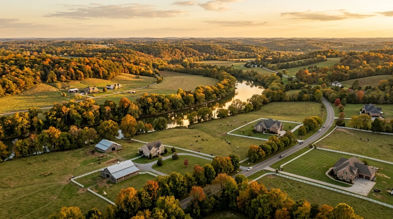
West Harpeth is not a city, a town or a single subdivision. The U.S. Geological Survey records West Harpeth as an unincorporated community beside West Harpeth Road, south of Franklin. It takes its name from the West Harpeth River, which rises near Thompson’s Station, flows northwest to the Leiper’s Fork area, then turns north past the west side of Franklin into the Harpeth River northwest of the city. People also use it loosely for the land along that river, for West Harpeth Road south of Franklin, and, on some home-search sites, for established streets on Franklin’s west side.
That matters. A home described as being in West Harpeth can sit inside the City of Franklin, inside the Town of Thompson’s Station, or in unincorporated Williamson County, and which one decides the tax bill, the school district and the rules for the land.
The Quick Take: West Harpeth in 2026
- No official boundary. We could not find West Harpeth defined as a neighborhood by the City of Franklin or by Williamson County.
- Three possible governments. Points we checked fall inside Franklin, inside Thompson’s Station, or in unincorporated county land.
- The tax difference is real. On a home appraised at $1,000,000, 2026 rates put the yearly bill anywhere from about $3,250 to about $5,608 depending on which side of those lines it sits.
- Country land comes with country rules: county septic permits, greenbelt rollback taxes and, across large areas of the unincorporated county, a 2020 rezoning to one home per five acres.
Found a West Harpeth Listing? Let Us Check the Address First.
We will tell you which government, school district and tax rate apply to that exact property before you spend a weekend touring it.
Talk to Lorene and Our TeamWhere Is West Harpeth?
West Harpeth is the countryside along the West Harpeth River, west and southwest of Franklin. The name is used three ways.
The River
The U.S. Geological Survey lists a historical gauging station, “West Harpeth River near Leipers Fork,” where the river crosses Southall Road; it recorded daily flow from 1954 to 1961, and USGS gives its drainage area as 66.9 square miles. Downstream, USGS lists a series of stations named by river mile on Franklin’s west and northwest side, from mile 5.5 down to mile 1.3. By mile 1.3 the river drains about 115 square miles, and it joins the Harpeth River a short way beyond, northwest of Franklin. You can see the station record on the USGS site for station 03432500.
The Road
West Harpeth Road is a road of about five miles south of Franklin, running between Columbia Pike on the east and Carters Creek Pike on the west. The road crosses jurisdictions. When we checked points along it against the U.S. Census Bureau’s geocoder in October 2026, one stretch fell inside the Town of Thompson’s Station and the eastern end fell in unincorporated Williamson County.
The Listing Label
Some national home-search sites tag established subdivisions on Franklin’s west side as “West Harpeth.” We checked two of those addresses, on Clairmonte Circle and Hamlet Drive, against the Census geocoder in October 2026. Both were inside the City of Franklin and inside the Franklin Special School District for the grades below high school. Those homes have little in common with a farm on the river near Leiper’s Fork.
Is West Harpeth in Franklin?
Sometimes. It depends on the address, and a Franklin mailing address will not tell you: a listing that says “Franklin, TN 37064” can still be outside the city limits.
| Where the address sits | Local government | What it adds to the tax bill (2026) |
|---|---|---|
| City of Franklin | City of Franklin and Williamson County | City rate of $0.296 per $100 assessed on top of the county rate |
| Town of Thompson’s Station | Town of Thompson’s Station and Williamson County | Town rate of $0.103 per $100 assessed on top of the county rate |
| Unincorporated Williamson County | Williamson County only | County rate only, $1.30 per $100 assessed outside the Franklin Special School District |
The quickest way to check is to enter the street address in the U.S. Census Bureau’s geocoder, choose the option that returns geographies, and look for “Incorporated Places.” If Franklin or Thompson’s Station appears, the address is inside that city or town. If nothing appears, it is unincorporated county land. The property tax record will confirm it.
Property Taxes in West Harpeth: What the 2026 Rates Mean
Tennessee assesses a home at 25 percent of its appraised value, and the tax rate is applied per $100 of that assessed value. Williamson County completed a countywide reappraisal in 2025, and its published 2026 rate sheet sets these combined rates. The estimates below apply each one to a home appraised at $1,000,000, which is assessed at $250,000.
| Where the home sits | Combined rate per $100 assessed (2026) | Estimated yearly tax on a $1,000,000 home |
|---|---|---|
| Unincorporated county, outside the Franklin Special School District | $1.30 | About $3,250 |
| Town of Thompson’s Station | $1.30 county plus $0.103 town = $1.403 | About $3,508 |
| City of Franklin, outside the Franklin Special School District | $1.27 county plus $0.296 city = $1.566 | About $3,915 |
| Unincorporated county, inside the Franklin Special School District | $1.9773 | About $4,943 |
| City of Franklin, inside the Franklin Special School District | $1.9473 county and district plus $0.296 city = $2.2433 | About $5,608 |
Source: Williamson County, 2026 Williamson County Property Tax Rates; 25 percent residential assessment ratio per the Tennessee Comptroller. The yearly figures are our arithmetic, not a bill, and exclude any exemptions or special charges. This is general information, not tax or legal advice; confirm the figures for a specific parcel with the Williamson County Trustee or Assessor of Property.
The gap between the lowest and highest rows is about $2,358 a year on the same $1,000,000 house, and it follows the city and school district lines, not the West Harpeth name.
Schools: Zoning Depends on the Address
There is no single West Harpeth school zone. Zoning depends on the school district first and the zone lines second.
Inside part of the City of Franklin, the Franklin Special School District serves the grades below high school and Williamson County Schools assigns the high school. That is what the Census geocoder returned for the two west Franklin addresses we checked. The district’s own map page notes that its boundaries do not cover the entire city of Franklin, so being inside the city does not settle it.
Outside the Franklin Special School District, Williamson County Schools assigns every grade. On the zone maps the district posts on its school zones page, the countryside southwest of Franklin, including Southall Road, the Leiper’s Fork area and West Harpeth Road, sits in the Independence High School zone, while the river’s lower stretch northwest of Franklin falls in the Franklin High School zone. The elementary map splits the area among several zones, including Hillsboro, Pearre Creek, Winstead, Thompson’s Station and Walnut Grove. Those maps are dated June 2024, and zones can change, so confirm any address for the 2026-27 school year.
Williamson County Schools says plainly that the School Board sets zones and that they may change when a building runs over capacity or a new school opens. Before you write an offer, enter the exact address in the district’s Zoned School finder on that page, with the street type abbreviated, and confirm the result with the district. For how zoning works across the county, see our Williamson County Schools buyer’s guide.
Land, Septic, Greenbelt and Floodplain: What to Check on Acreage
Outside the city and town limits, these are the four questions we work through on every parcel.
How Much the Land Can Be Divided
In November 2020, Williamson County rezoned large areas of the unincorporated county to a maximum of one home per five acres outside the cities’ urban growth boundaries, according to the county’s own planning documents. Designated hamlets and areas with special area plans, including Leiper’s Fork, were excepted. If part of your plan depends on splitting off a lot later, confirm the parcel’s zoning with Williamson County planning before you buy, not after.
Septic
In Williamson County, septic is regulated by the county’s own Department of Sewage Disposal Management under regulations first adopted in 2000 and amended as recently as August 2026. The detail that catches buyers: where an existing system cannot be documented in public records, the county will not approve a remodel, rebuild or addition to the house it serves until soils for a repair or back-up area are identified on a plat or soil map. Ask for the septic permit and soil map early, especially if you plan to add bedrooms.
Greenbelt
Tennessee’s greenbelt program taxes qualifying land on its present use rather than its highest and best use, which can lower the bill on a farm or wooded tract considerably. Agricultural and forest classification requires at least 15 acres, and open space requires at least three acres. If the land is later converted or disqualified, rollback taxes come due for the savings of the preceding three years for agricultural and forest land, or five years for open space. First-time applications go to the county Assessor of Property by March 15. Read the Tennessee Comptroller’s greenbelt summary, and settle in the contract who carries any rollback exposure.
Floodplain
Land near the West Harpeth or its tributaries can include mapped floodplain, which affects where you can build and whether a lender requires flood insurance. Look up the parcel on FEMA’s Flood Map Service Center and ask for any survey or elevation certificate the seller has. Confirm too whether the home is on public water or a private well, because that varies by parcel.
Buying Land Near Franklin? Get the Parcel Facts Before the Offer.
We pull the jurisdiction, school zoning, greenbelt status and septic records on the specific parcel so you know what you are buying.
Talk to Lorene and Our TeamWyelea: The Planned Community on the West Harpeth River
One new development on the river is Wyelea. According to its developer, Wyelea covers about 600 acres with a Franklin, Tennessee address, with 68 homesites and one 50-acre homestead spread along more than two miles of West Harpeth riverfront. As of October 2026 the developer lists one- to ten-acre homesites from $1.5 million, and says each home will be designed by a group of regional architects. The developer describes a private members club still to come, with equestrian facilities, riding trails, racquet sports, swimming, fitness and dining.
Treat those as the developer’s plans, and for any homesite ask which jurisdiction it sits in and what the club membership requires.
How Far Is West Harpeth From Franklin, Leiper’s Fork and Nashville?
Because West Harpeth has no center, distance depends on where you start. Here are two reference points, measured as approximate road miles with OpenStreetMap routing in October 2026. Drive times vary with traffic, especially into Nashville at rush hour.
| Destination | From the river at Southall Road | From West Harpeth Road in Thompson’s Station |
|---|---|---|
| Public Square, downtown Franklin | About 7 miles | About 10 miles |
| Leiper’s Fork village | About 2 miles | About 10 miles |
| Tennessee State Capitol, downtown Nashville | About 29 miles | About 32 miles |
West Harpeth Compared With Nearby Options
These are the places we most often put side by side with West Harpeth.
- Westhaven is a master-planned community inside the City of Franklin on the west side of town, with a walkable village center and smaller lots. See our Westhaven guide.
- Legends Ridge is a gated community northwest of Franklin, in unincorporated Williamson County, where lots run about an acre and up, per Lorene’s October 2026 comparison of Franklin’s luxury neighborhoods.
- Arrington, on the southeast side of the county, is the other place Williamson County buyers look for estate land.
- Thompson’s Station is an incorporated town whose limits reach toward West Harpeth Road, with its own town tax rate of $0.103 per $100 assessed in 2026.
- Leiper’s Fork is the village about 2 road miles west of the river at Southall Road, with its own special area plan in the county’s planning.
For the full Franklin picture, start with Living in Franklin, TN: The Complete Guide, and for estate land compare our Arrington acreage guide.
What Homes Cost in West Harpeth
There is no reliable single price for West Harpeth. The name covers subdivision homes inside Franklin, rural tracts in the county and new homesites like Wyelea’s, so a blended average mixes things that do not belong together. Ask for recent sales on the specific road or subdivision; we pull those from the MLS.
How to Check a West Harpeth Property Before You Offer
- Jurisdiction: inside Franklin, inside Thompson’s Station or county only.
- School district and zoned schools for the exact address.
- The matching 2026 tax rate applied to the appraised value.
- Septic permit, soil map and repair area, or the sewer connection.
- Greenbelt status and who carries any rollback taxes.
- Floodplain on FEMA’s Flood Map Service Center.
- Zoning, and how many homes the parcel can hold.
Frequently Asked Questions About West Harpeth
Where is West Harpeth, TN?
West Harpeth is an unincorporated area of Williamson County, Tennessee, south and southwest of Franklin. USGS records it as a community near West Harpeth Road, and the name also covers the countryside along the West Harpeth River, which rises near Thompson’s Station, flows northwest to the Leiper’s Fork area and then north past the west side of Franklin to join the Harpeth River northwest of the city. Some home-search sites also use it for streets on Franklin’s west side.
Is West Harpeth a city or a neighborhood?
Neither in an official sense. West Harpeth is not an incorporated city or town, and we could not find it defined as a neighborhood with a boundary by the City of Franklin or Williamson County as of October 2026. The U.S. Geological Survey lists it as an unincorporated community near West Harpeth Road south of Franklin, named for the West Harpeth River, with no legal boundary.
Is West Harpeth inside Franklin city limits?
It depends on the address. In October 2026 Census geocoder checks, two west Franklin addresses labeled West Harpeth were inside the City of Franklin, a stretch of West Harpeth Road was inside the Town of Thompson’s Station, and the river near Leiper’s Fork was in unincorporated Williamson County. A Franklin mailing address does not mean the home is inside the city.
What are property taxes in West Harpeth?
They depend on the jurisdiction. Using Williamson County’s 2026 rates and Tennessee’s 25 percent residential assessment, a home appraised at $1,000,000 would owe about $3,250 a year in unincorporated county land outside the Franklin Special School District, about $3,508 in Thompson’s Station, about $3,915 in Franklin outside that district, and about $5,608 in Franklin inside it. These are estimates, not tax advice; confirm with the Williamson County Trustee.
What schools serve West Harpeth?
There is no single zone. Parts of the City of Franklin are in the Franklin Special School District for the grades below high school, with Williamson County Schools assigning high school. Outside that district, Williamson County Schools assigns every grade, and its posted maps (dated June 2024) place the countryside southwest of Franklin, including West Harpeth Road and the Leiper’s Fork area, in the Independence High School zone and the river’s lower stretch northwest of Franklin in the Franklin High School zone, with elementary zones including Hillsboro, Pearre Creek, Winstead, Thompson’s Station and Walnut Grove. Confirm any address in the district’s Zoned School finder.
Can you split land in West Harpeth into more lots?
Often not much. In November 2020 Williamson County rezoned large areas of the unincorporated county to a maximum of one home per five acres outside the cities’ urban growth boundaries, with exceptions for designated hamlets and special area plans such as Leiper’s Fork. Confirm the zoning of the specific parcel with Williamson County planning before you buy.
Do homes in West Harpeth use septic systems?
Many rural homes in Williamson County do, and the county’s Department of Sewage Disposal Management regulates them. If an existing system cannot be documented in public records, the county will not approve a remodel, rebuild or addition until soils for a repair or back-up area are identified on a plat or soil map. Ask for the septic permit and soil map before you offer.
What is Wyelea?
Wyelea is a planned community on the West Harpeth River with a Franklin address. According to its developer, as of October 2026 it covers about 600 acres with 68 homesites and one 50-acre homestead along more than two miles of riverfront, lists one- to ten-acre homesites from $1.5 million, and plans a private members club with equestrian facilities, trails, racquet sports, swimming, fitness and dining.
How far is West Harpeth from downtown Franklin and Nashville?
From the West Harpeth River at Southall Road near Leiper’s Fork, it is about 7 road miles to the Public Square in downtown Franklin, about 2 miles to Leiper’s Fork village and about 29 miles to the Tennessee State Capitol in Nashville. From West Harpeth Road in Thompson’s Station it is about 10 miles to the Public Square and about 32 miles to the Capitol. Distances measured with OpenStreetMap routing in October 2026.
Continue Exploring Franklin and Williamson County
- Arrington, TN: Williamson County’s Estate and Acreage Market
- Westhaven, Franklin TN Neighborhood Guide
- Living in Franklin, TN: The Complete Guide
- Thompson’s Station, TN: Neighborhood and Buyer’s Guide
- Legends Ridge, Franklin TN Neighborhood Guide
- Franklin TN Luxury Neighborhoods Compared (2026)
- Williamson County Schools: A Buyer’s Guide
Social Cookies
Social Cookies are used to enable you to share pages and content you find interesting throughout the website through third-party social networking or other websites (including, potentially for advertising purposes related to social networking).